PROGRAM
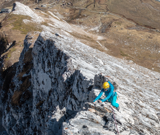
At the bottom of the Val Veny, just before the vast depression of the Col de la Seigne, two small white peaks delineate a rocky ridge completely out of context in the undisputed realm of granite typical of the Aosta Valley region. They are called the “Pyramides Calcaires”. The limestone section is mainly located on the north-east Pyramid. The south-west peak is made up of metamorphic rocks.
GROUP DEPARTURES
Difference in altitude: 600 m
Ascent/descent time: 3-5 hours
Meeting point: Skyway cable car parking area at 9.00 a.m. for equipment check and a short briefing. Transfer by car to Val Veny.
From the Elisabetta Refuge you can easily reach the start of the route. Through a panoramic path that climbs through meadows and stony ground in the splendid valley bordered by the limestone ridge of the Pyramides, located at an altitude of about 2600 meters. The view from the ridge is unmatched. To the north the peaks of Mont Blanc, Aiguille de Trélatète and Aiguille de Glaciers tower majestically. On the French side, the Vanoise and the Beaufortain stand out. The descent, on the southwest side, leads to the Tour de Mont Blanc path. And then back to the refuge through an initial steep path on rather unstable rocky terrain. The itinerary presents a constant difficulty. Some more demanding passages in the lower half, but always well protected. Suitable also for mountaineers at the first experiences. Just before the summit, you face a short but delicate downhill passage. It offers the possibility of a short descent on rope. The itinerary descents the valley to the north of the ridge traveled (often covered with snow until July). Another option is to the south, towards Alpe Superiore de la Lex Blanche, on the path that leads from the refuge to Col de la Seigne.
DETAILS
RATES
- liability insurance
The rate does not include
- research and rescue insurance with UVGAM coverage (recommended): €5 per person for 3 days
- transfers, meals and accommodation
- anything that is not mentioned under "The rate includes"


